WILLIAM STEWART
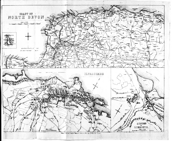
William Stewart took over John Banfield‘s business (c.f.) and library circa 1872 and began to issue the same guide books as Banfield based on the work of Tugwell. Although Banfield had already used a map of the North Coast of Devon, Stewart had a new map made including plans of both Ilfracombe and of Lynton with Lynmouth. This was lithographed by Charles King of Exeter. Stewart’s map may well have been based on the similar map by Besley which was first published at about the same time as King also lithographed Besley's map (see Besley 7). This map was replaced by an identical map c. 1878 (see next entry).
For Stewart´s map 1 executed by Charles King see below.Stewart 1
Size: 305 x 385 mm (total). SCALE OF MILES (10 = 75 mm).
Three maps on one sheet: COAST OF NORTH DEVON (scale as above). There are town maps of ILFRACOMBE (155 x 260 mm; SCALE OF CHAINS 5 + 10 = 37 mm) and LYNTON AND LYNMOUTH (155 x 125 mm; SCALE OF CHAINS 5 + 20 = 50 mm) below. Imprint: Published By W Stewart, Bookseller, Stationer &c. Arrival List Office, High Street Ilfracombe, 7 June 1872. (CeOS). Printer's signature: Chas King, Lith, 8 Alma Terrace, St Sidwells, Exeter. (EeOS). Illustrated.
The map shows the coast from Hartland to Minehead. Railways to Ilfracombe, and Barnstaple to Taunton.
1. 1872 Stewart's (late Banfield's) Shilling Guide Book to North Devon: Eighth Edition
Ilfracombe. W Stewart. 1872. TQ, BL[1] .
The North Devon Handbook: Second Edition [2]
Ilfracombe. John Banfield (William Stewart ). (1876). KB.
2. 1872 Printer's signature deleted.
Stewart's Guide to the North of Devon ...The North Devon Guide ... Ninth Edition
Ilfracombe. W Stewart. (1872). KB.
Stewart's Shilling Guide Book to North Devon... Ninth Edition
Ilfracombe. W Stewart. (1876)[3]. KB.
Stewart's Shilling Guide Book to North Devon... New Edition
Ilfracombe. W Stewart. (1876)[4], (1880). KB; DevA.
The North Devon Handbook: Fourth Edition
London: Simpkin, Marshall, And Co. Ilfracombe: W Stewart. (1877)[5]. KB, BL.
[1] BL catalogue
has two titles; Banfield's shilling guide-book to
North Devon ... Third edition and Stewart's (late Banfield's) six-penny guide-book
to North Devon Eighth edition. BL YA.2000.a.14944.
[2] Edition is same as Banfields’s Second Edition
with substitution of Stewart for Banfield on cover title only. Also contains a second
map of North Coast, see Banfield 5.
[3] Identical
to the New Edition below, probably earlier
and title page amended to sound more up to date.
[4] Although
the map is dated 1872, the copy known (KB) has a text with latest date of 1876.
The text is that of the earlier editions with a number of additions. The Eighth
Edition has list of charges dated 2nd August 1867 on pages 35-36.
The Ninth Edition and the New Edition have information on a new aisle
of 1876 on page 38.
[5] Exeter has a copy with Stewart 2, a close copy of this map.


No comments:
Post a Comment